Norris Geyser Color
The Norris Geyser Basin 44°43′43″N 110°42′16″W is the hottest geyser basin in the park[7] and is located near the northwest edge of Yellowstone Caldera near Norris Junction and on the intersection of three major faults. The Norris-Mammoth Corridor is a fault that runs from Norris north through Mammoth to the Gardiner, Montana, area. The Hebgen Lake fault runs from northwest of West Yellowstone, Montana, to Norris. This fault experienced an earthquake in 1959 that measured 7.4 on the Richter scale (sources vary on exact magnitude between 7.1 and 7.8; see 1959 Yellowstone earthquake). Norris Geyser Basin is so hot and dynamic due to the fact that these two faults intersect with the ring fracture zone that resulted from the creation of the Yellowstone Caldera of 640,000 years ago.[8]
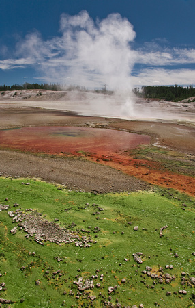
The Basin consists of three main areas: Porcelain Basin, Back Basin, and One Hundred Springs Plain. Unlike most of other geyser basins in the park the waters from Norris are acidic[9] rather than alkaline (for example, Echinus Geyser has a pH of ~3.5). The difference in pH allows for a different class of bacterial thermophiles to live at Norris, creating different color patterns in and around the Norris Basin waters.
The Ragged Hills that lie between Back Basin and One Hundred Springs Plain are thermally altered glacial kames. As glaciers receded the underlying thermal features began to express themselves once again, melting remnants of the ice and causing masses of debris to be dumped. These debris piles were then altered by steam and hot water flowing through them. Madison lies within the eroded stream channels cut through lava flows formed after the caldera eruption. The Gibbon Falls lies on the caldera boundary as does Virginia Cascades.